I went to Karimganj for the first time in the summer of 2009. This was a couple of months after our wedding, which had taken place in Kolkata. The joining call from KMDA had come soon after the marriage. I had an idea – why not spend a week in Karimganj with Durba before taking up the new job? After all, I hadn’t met a lot of her folks yet. So it was decided that we would be flying out the day after I quit my job at IPMSL Silchar (IXS) is one and a half hour by flight from Kolkata – Karimganj is a further three hour drive west from here. Durba says that it was once possible to cover the 80 odd kilometres from Silchar to Karimganj well under two hours – the National Highway today is in a sad state of disrepair.
Kolkata was reeling under an unusual spell of dry heat at the time. When we reached Dum Dum to board our flight a little before five in the morning, the temperature had already shot up to 37◦ C. We boarded one of Alliance Air’s rickety small ATRs. Half an hour into the flight, flying over Bangladeshi air space, we could see a wall of towering clouds to our left. We seemed to be making a detour to avoid the formation. But after sometime, we were flying right through it, the aircraft rocking violently from the resultant turbulence.
I had flown in ATRs quite a few times earlier during my Kolkata - Raipur trips on office work. I knew it could get bumpy in these turboprops. But this was beyond my worst nightmare! Surprisingly, everyone else on board, and that included Durba, seemed to be quietly relaxed. The turbulence subsided after half an hour. Durba said that this was perfectly normal on this route for this time of the year. Well, that seemed to explain the calm in the cabin all through – old hands on board, all except poor me!
The final approach to Silchar is accompanied by a bird’s eye view of the river Barak meandering in and out of the city. As we descended, I could see that it was raining. Sweeping in over the lush green slopes of the tea estate adjacent to the airport, we made a bumpy landing, banging into the runway almost. That could have been due to the rain and wind shear. Good piloting in the end. No wonder our pilots had looked so senior - the terrain and the vagaries of nature in these parts call for hugely experienced crew.
Kumbhirgram airport, Silchar, is a civilian enclave within an IAF base. We were greeted by a drizzle as we walked out on to the tarmac. The temperature display on the terminal building read 20◦ C. I couldn’t believe my eyes! The scorching heat of Kolkata seemed like a distant dream! We collected our luggage and boarded a taxi to Silchar. Here it is normal to share a run-down old Amby with seven others excluding the cabbie!
 |
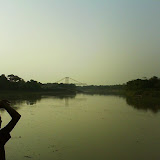
| From Karimganj, April 2009 |
A fairly large city with a Municipal Corporation, Silchar is the headquarters of Assam’s Karimganj district. Home to a Central University (Assam University) and a National Institute of Technology (NIT, Silchar), it is a major prescence in the Indian higher education map. I probably wouldn’t be wrong if I said that it is the nerve centre of the Barak Valley, and the Bengali-speaking belt of Assam. It is around 26 km from the airport to the centre of the city. On the terminal building at Kumbhirgram, the airport’s name is written in Bangla, besides Hindi and English. Almost all shop-fronts have names written in Bangla. Sometime in the early sixties, discontent brewed in this region as Bengalis protested the Assam government’s move to make training in the Assamese language compulsory. Eleven people died in police firing at the Silchar railway station during an agitation over the issue.
Silchar (SCL) is connected by a metre gauge track to Lumding (LMG), the nearest broad gauge railhead, on the Guwahati – Dibrugarh line. The distance is 210 km – 29 km to Badarpur Junction (BPB) and from there, another 181 km to LMG. The service on what is supposed to be one of the most picturesque routes in the country, is not very reliable, thanks to occasional militant activity and landslides. The same metre gauge track connects SCL to Agartala (AGTL), Tripura’s capital, again via BPB. The SCL – AGTL distance is 252 km.
Karimganj (KXJ) lies on the SCL – BPB – AGTL line. The SCL – KXJ distance is 49 km. Karimganj town, situated right on India’s border with Bangladesh, is the headquarters of a district of the same name, neighbouring Cachar district. On the route from Silchar to Karimganj lies a small town called Panchgram, somewhere after Badarpur. It is home to the Cachar Paper Mill, a unit of the Hindustan Paper Corporation Ltd., a Central Government PSU. It is the only large industrial unit in the region.
So, passing through Silchar, Badarpur and Panchgram, we finally reached Karimganj, where a warm welcome awaited us. I remember that it rained and rained for the rest of the trip, and I slept a lot, cool as the weather was! I would like to mention here an outing we made one afternoon to Sutarkandi, a border post close to Karimganj town where we saw the newly constructed border trading post which can potentially stimulate the economy of the region. In the evening twilight we watched from across a barbed wire fence the fields and trees of another country, a country so similar to our own, a country where we had our roots – it was an emotional end to that day’s tour.
View Kumbhirgram Airport - Silchar - Karimganj route in a larger map
Tour Album
 |
| Karimganj, April 2009 |
No comments:
Post a Comment